Needham History: A Picture is Worth…
How quickly it transformed our town.

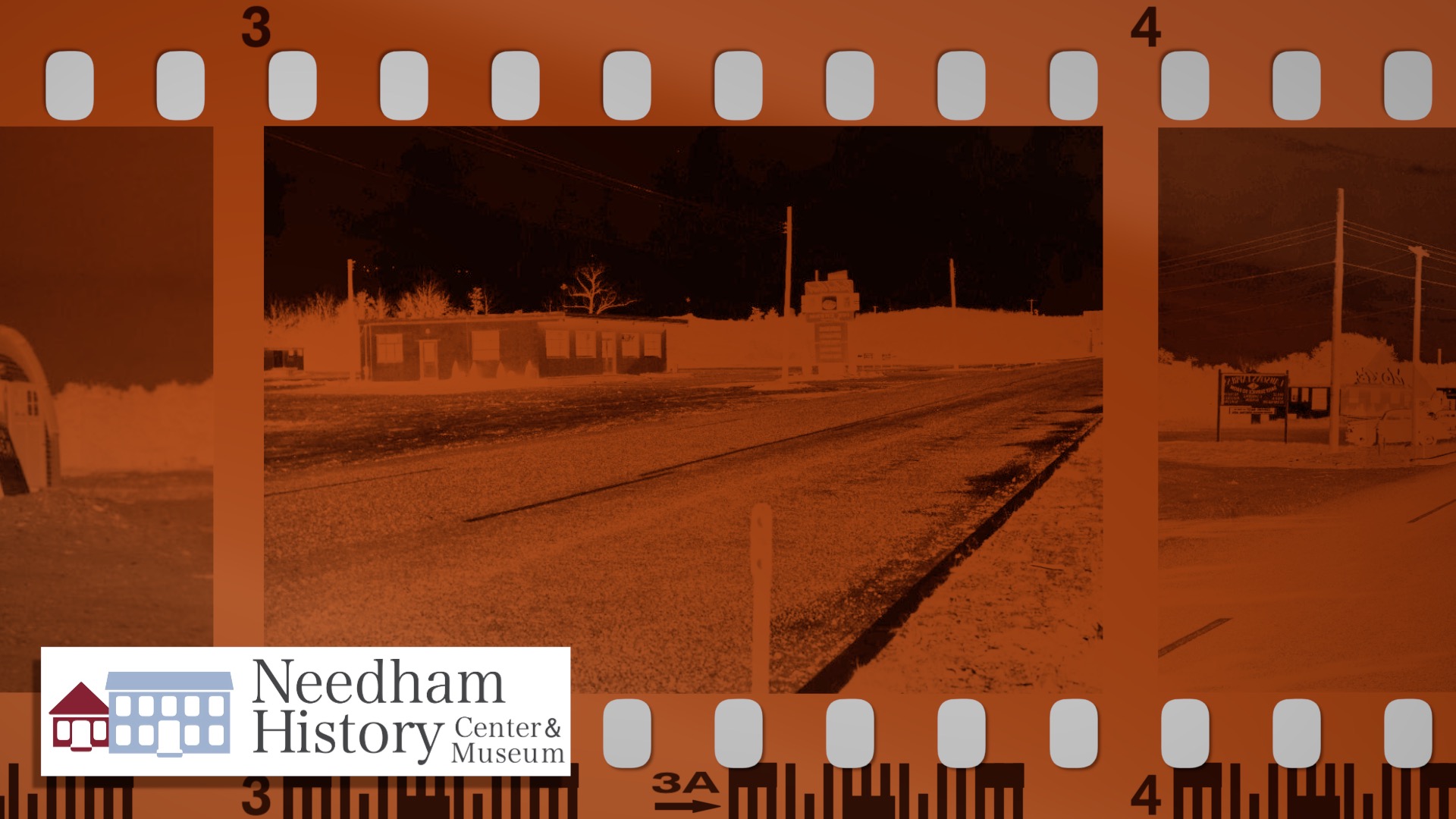
Reservoir Street (formerly part of the Circumferential Highway) looking north before Route 128 was built, circa 1953. The first intersection on the left is Kearney Road. The white building on the left is The Salad Bowl, the Moxie Labs is on the right, and Orciani’s Texaco is beyond that.
A Picture is Worth…
I posted these pictures some years ago, and at the time asked for comments from anyone who remembered the area in the day. And I got great responses – so thank you all! – and have learned more since then. The pictures show the old Circumferential Highway (Greendale Ave to Reservoir Street) before Route 128 was built, and when that stretch of the road was still Reservoir Street at the intersection of Kearney Road. The pictures date to 1953. The highway was built over this section in 1954. What do we see?
Reservoir Street – The street seen in the pictures is Reservoir Street in its original configuration, when it ran from the corner of Kendrick Street and Greendale Avenue to its current northern end at Route 9. At the time of this photo the modern highway was not yet built in this section, so Greendale and Reservoir were still part of what was known before the War as the Circumferential Highway, a designated route from Canton to Peabody that was meant to circle around the old Boston hub-and-spoke road system. A year or so after this picture, by about 1954, the roadway was cleared and broadened into the current highway that we so love to hate.

Above: The same spot looking south, with a better view of The Salad Bowl. The old railroad trestle, which was taken down about 10 years ago, is visable at the left margin of the picture.
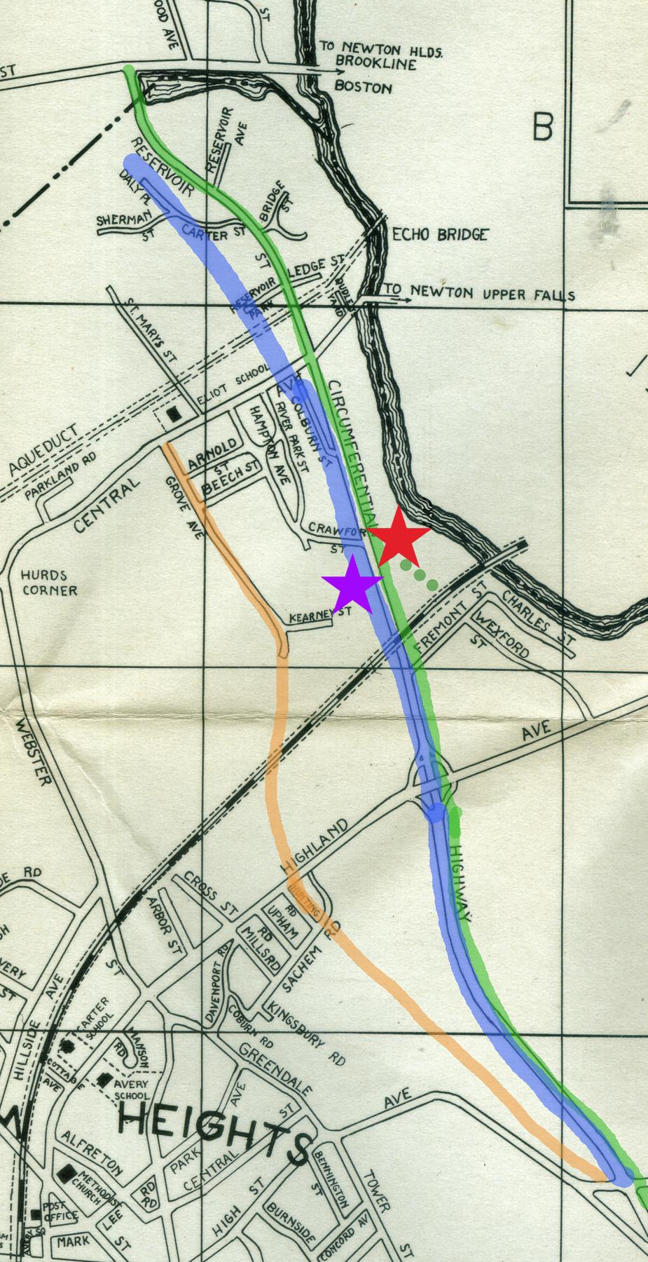
Below: A map showing the approximate location of the various roads as they changed. The green line is Reservoir Street in its original configuration; the green dots show where it was diverted into Riverview Street to form its current route. The blue line is Route 128, which ran over the path of southern Reservoir Street. The pink is the route of the new Hunting Road, which took over as the surface route in this section after the highway was built. The red star is the location of Moxie Labs in the first picture (still there), and the purple star is the location of The Salad Bowl.
Because the southern half of Reservoir Street lay right on the new Route 128 path, the road had to be diverted. Near the north end of Reservoir Street, the highway overran or shortened Sherman Street, Daly Place, Reservoir Park, and Carter Street. Some of the houses were demolished, and others were moved to nearby streets. From about the intersections of Carter and Bridge Streets, and across Central Avenue to the waterworks, it is the same old road; but at that point the highway took over the road bed and Reservoir was diverted onto a small side street called Riverview Street. In the first picture, Riverview Street is the lane off to the right that is indicated by the Dawson’s Delivery sign.
Since Reservoir Street linked up with Highland Avenue, a new surface road was needed to cover this route. Both Hunting Road and Grove (later Gould) Streets were small roads; Hunting was extended to join Grove, forming the main north-south road along the highway and roughly parallel the old route of Reservoir Street.
The Moxie Building – Moxie is allegedly a soft drink, a rather gruesome concoction – sorry, an acquired taste – that was introduced in 1876 as a patent medicine, “Moxie Nerve Food.” It is flavored with gentian root and tastes like a mixture of root beer, orange soda, grape soda, and a little bit of licorice. But not in a good way. It is the first mass-produced soft drink in the US, originally in Lowell but now in Bedford, NH. For a while in the 1960s it was bottled at the Coke plant in Needham Heights. The Moxie Beverage Company was acquired by the Coca-Cola Company as a subsidiary in 2018. It is the official soft drink of Maine. You can buy it at Roche Brothers, if you must.
The “Moxie Laboratory” opened in Needham on Reservoir Street in 1953, producing the syrup and concentrate for soda fountains and later bottling plants. Ted Williams was a commercial spokesman, but the brand began to struggle. The brand was purchased by Monarch Beverages of Atlanta in 1966, and operations in the Needham site were closed around 1970. The building is still in its original location, and is now the location of Forklift Catering. The highway now runs in front where Reservoir Street was, and the relocated Reservoir Street is now behind it. The Texaco station beyond Moxie was owned by Elmo Orciani; like a good neighbor, he sold Moxie – the sign is visible in his window.
The Salad Bowl in its quonset-hut structure – on the corner of Reservoir and Central?

The Salad Bowl was a small restaurant owned by the Leeber family. One writer remembers working there as a teen for “30 cents an hour and all the Coke he could drink.” The Salad Bowl, as its extensive sign proclaimed, served steaks and chops, seafood, fried chicken, and ice cream.
The Salad Bowl was across the street from Moxie, where Van Millwork and Bin Ends are now located, between Kearney Road and the driveway of Nigosian Rug. Route 128 shortened Kearney Road and Crawford Street, and eliminated Colburn Street altogether.
There is another picture of The Salad Bowl that is also from the early 1950s, which shows a Quonset-hut structure on Reservoir Street at the intersection of Central Avenue, on the site that was most recently Brothers Pizza (I think?). This one seems to be a farm stand rather than a restaurant. I don’t know whether the Quonset hut preceded the restaurant, or vice versa (if anyone knows, send me a note!)
Muzi Motors in its original location, at the southern end of Reservoir Street, circa 1950.
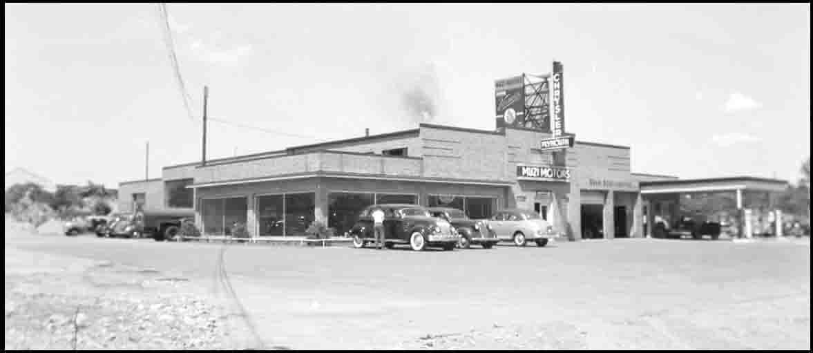
Elsewhere on Reservoir Street – The current Riverbend Office Park was the former Moerschner Dye Works. They dyed silks, which came from the old silk mill at Upper Falls (the location of the former Mills Falls Restaurant in the Echo Bridge Mall). The company was at that location at least by the 1940s, and lasted at least into the 1960s. Reservoir Street was also the original location of Muzi Motors, which (I am told) moved to its Gould Street location in a land swap when the highway took its land. Other places mentioned were Tocci’s Barber Shop, the Stewart Knife Company, McCulloch’s garage (Mobil), Vara’s garage/gas station (which I knew for years as Kiser Automotive), and Sam’s egg farm near the corner of Bridge Street.
We are used to Route 128 running through the edge of Needham, and we all use it constantly, even to go short distances. It is easy to forget what a transformative event the highway was, and how profoundly it altered the character of the town – geographically, demographically, and functionally – in a very short period of time.
| Gloria Polizzotti Greis is the Executive Director of the Needham History Center & Museum. For more information, please see their website at www.needhamhistory.org. |