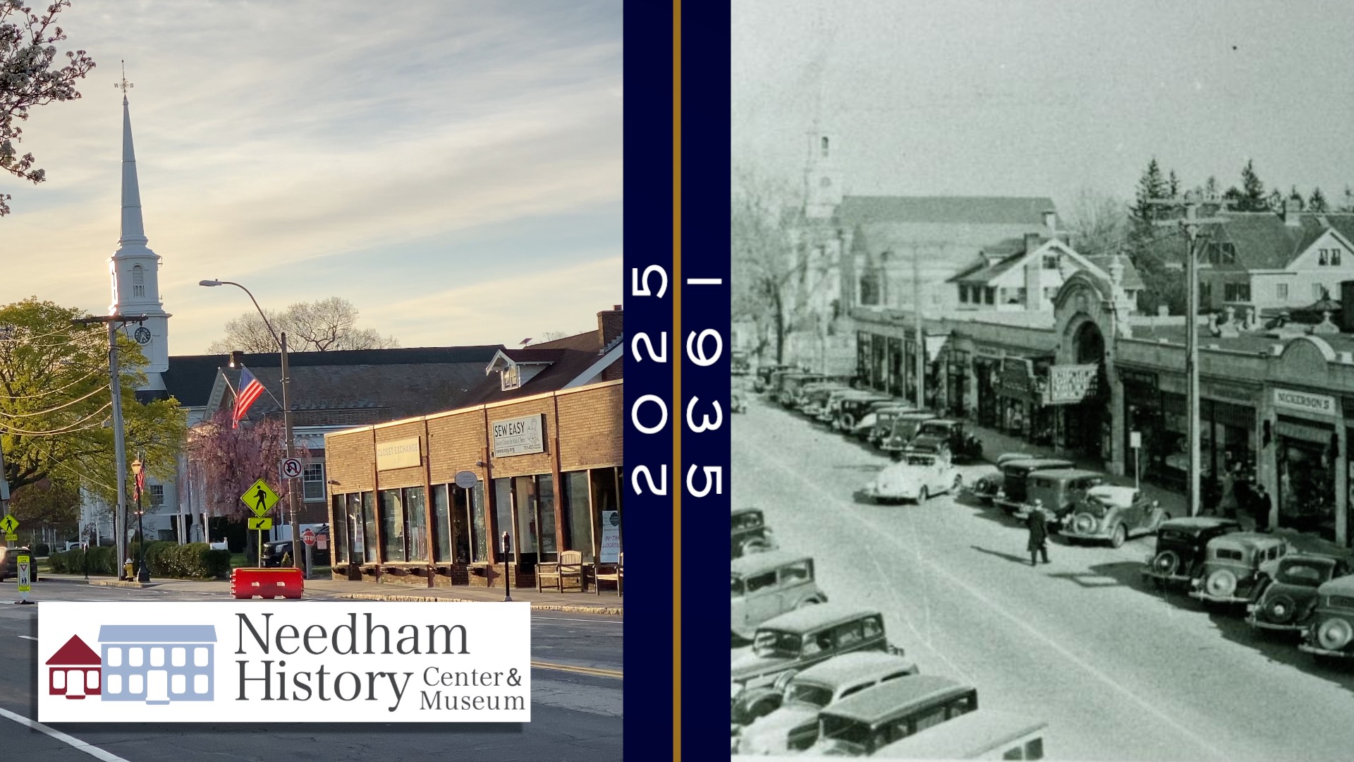
Needham History: A Tour of Downtown Needham in 1935
Strolling thru the downtown on a spring afternoon in 1935.
A Tour of Downtown Needham in 1935
In our wonderful collection of photos, we have a good number of pictures of the Center business district over the years from about 1880 until recently. There is one little collection that stands out – a series of photos taken on the afternoon of April 6, 1935. The photos were taken by the Department of Public Works, and apparently used as an assessment of road use and traffic, at a time when cars were becoming ubiquitous. Many of them were taken from the steeple of the First Parish church, a great vantage point for the downtown streets; others clearly not – maybe the Town Hall, a crane, or other structure?

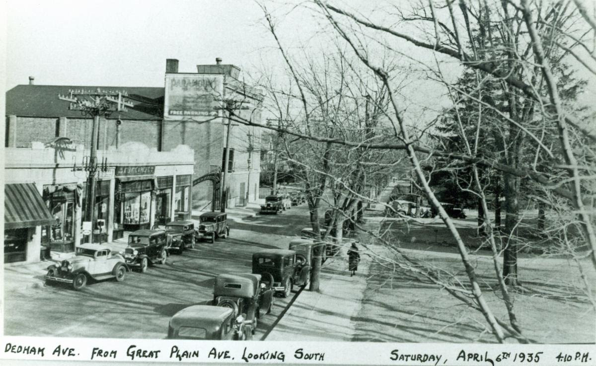
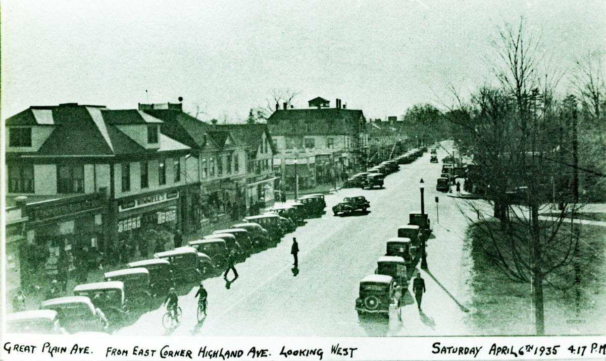
Let’s start with this one – a view down the south side of Great Plain Avenue between Dedham Avenue and Warren Street. At the right hand margin in Plummer’s Pharmacy, which sold (among other things) Ex-Lax (prominently etched on its windows) and Partridge’s Ice Cream. Next to Plummer’s is the Atlantic and Pacific Tea Company, or as we all knew it – the A&P. The A&P moved location several times before it closed in 1975 when it could no longer compete with the other supermarkets in town – Roche Bros, Stop & Shop, and First National. Next to the A&P is Nickerson’s, a men’s clothing store, which was open until the 1960s. The rest of the signs are too hazy to read, but several landmarks stand out. The fancy façade of the Needham Paramount Theater with its projecting marquee (can’t read what’s playing!) dominates the block; the main bulk of the theater can be seen behind the A&P. The theater opened in 1926 and closed in 1989 over an ownership dispute and the industry move to large multi-plex cinemas. Though the theater has been demolished, parts of the façade of the storefront between Plummer’s and the theater were preserved when the block was rebuilt. Beyond the Cinema can be seen the roof of the house that was formerly Hillcrest Gardens, the Christian Science Reading Room, and the Baptist Church (which had been moved to that location in 1928).

This is the view directly across the street from the last one. Apart from the occupant businesses, this stretch has barely changed since it was built in 1929. At the very left edge is the Needham National Bank; this corner building has been one bank or another since it was built in 1929. It was formerly (from 1855 until 1928) the site of the Baptist Church before it was moved farther up Great Plain Avenue to its current location. The first awning next to the bank is the Arthur B. Probst Company, which sold greeting cards. Next to that is Brown’s Market (“Meats, Fish and Groceries”) and then the Needham Square Restaurant. The rest are too blurry to read (one appears to say “Creamery”), but the large roof is the building that currently houses several salons and Doris Couture, as well as Vita Needle, which had opened in the upper floors in 1932.
Pivoting 90 degrees south, this is a view down Dedham Avenue. The A&P has an entrance here as well (last windows before the alley archway); the store went through the block and could be entered from either side. Beyond the arch is the bulk of the Needham Paramount Theater, which advertises Free Parking. The parking might have been through the metal archway, which led to an open lot; the rest of Dedham Avenue appears to be houselots at this time.
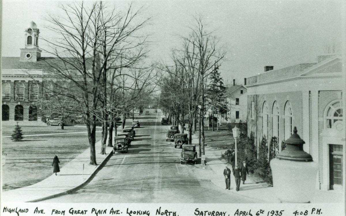
Turning 180-degrees from the last picture, this is the view northward down Highland Avenue. The Town Hall and Common were built in 1902. This is a better view of the Needham National Bank, at the right margin. The Needham National Bank was in business until at least the late 1970s, and the building later became a Shawmut Bank, Fleet Bank, Sovereign Bank, and is currently Santander. Beyond the bank are some rather nice houses. This stretch was desirable real estate from about the 1870s until the 1930s, but became desirable retail space instead as the downtown developed.
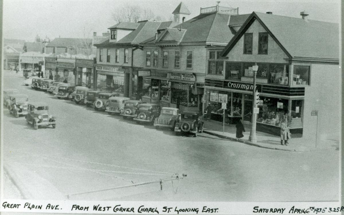
Turning west, this view looks down Great Plain Avenue from the National Bank corner toward Chestnut Street. The first readable sign is Rimmele’s Market, and on the corner is Crossman’s Market. Both Rimmele’s and Crossman’s were downtown grocery stores in business though several generations from the late 19th century through the mid-20th. Crossman’s location would later become the first Roche Brothers store in Needham (1959-1965, when they moved up Chestnut Street), and then Harvey’s. Beyond the Chestnut Street intersection, the large building was the Kingsbury Block, one of the last survivors of the early retail development of the Great Plain. It was built in 1887 as the Great Plain was growing as our new downtown, and was destroyed in a fire in 1980. The one-story storefronts surrounding it were built in the 1920s. There are also a remarkable number of people in this picture, and the sidewalk seems quite crowded. There is a policeman in the middle of the street, but he does not seem to mind the man who is jaywalking.
This is the same block, from the opposite angle, looking east. It is a better view of Crossman’s (Veal Legs 29 cents a pound!) and Rimmele’s. Between the two grocery stores were a Rexall drug store (selling Hood’s ice cream) and Dorothy Muriel’s Food Shop (lotta food options on Great Plain Ave.) Although it looks different now from the street, the buildings on this block have not changed much either. The corner store where Crossman’s was burned down in 1977, and was rebuilt into the current brick block. The buildings that now house Barre 3 and Masala Art are the same ones that once housed Rimmele’s and Dorthy Muriel’s, and the ones beyond to the Farmhouse corner are the same as well. Over the years their fronts have been altered with a brick facing, but I you look up at the roof lines, you can see that the old buildings (built around 1895) are still there.

The last image is a view from Crossman’s corner looking south down Chestnut Street. There appears to be a gas pump in front of the business next to Crossman’s, but I can’t read the sign. The next building over was another grocery, the First National Stores, and beside that was the old Post Office, which was located there until the current PO was built in 1971. The narrow doorway to the left of First National was, then as now, the Needham Bowlaway, which opened in 1917 when the building was built. Beyond the post office is a row of stores (still with us), though the access between was then a small residential street known as Chestnut Road. That space later became a town parking lot, and Chestnut Road became its driveway; since 2001 it has been the pedestrian passage dedicated to police officers Frank Haddock and Forbes McLeod. The current Middlesex Bank site was residential (you can just see the roof), and beyond that is the cupola of the recently-replaced fire and police station.
I love these photos for so many reasons. The cars! Cars were certainly more stylish then – but good grief! – we have been clogging up GPA with traffic for almost 100 years. And although the streetscape is the same enough to be familiar, it is also different enough to clearly belong to another time. But most of all, because these pictures are a set that show the downtown from all angles at the same time. We have many other views of these streets and storefronts, but they are years and sometimes decades apart. To me, this is like taking a stroll through downtown Needham on a chilly spring Saturday in 1935.
The original negatives of these photos are kept in the Department of Public Works, and we thank them for giving us copies for our collections. And many thanks to Polly Attridge, our Archivist, who over the years has researched the businesses that are shown here.
| Gloria Polizzotti Greis is the Executive Director of the Needham History Center & Museum. For more information, please see their website at www.needhamhistory.org. |