Needham History: The Oldest Photos of Needham
These are the ghosts of Needham’s past.
 The Old Center, circa 1870. The image shows (right to left) the First Parish Church, Revere Hall, the Center (“Brick”) Schoolhouse, and the Israel Whitney House (1830).
The Oldest Photos of Needham
The Needham History Center is fortunate to have a really amazing collection of photographs, roughly 6000 of them (and thank you, Polly Attridge, for cataloguing them all!)
The very oldest are daguerreotype portraits from the 1840s. According to George Kuhn Clark’s History of Needham, a “Mr. Talbot” took the first daguerreotypes in Needham, making his headquarters at the tavern in 1842. Mr. Talbot was truly a pioneer – Louis Daguerre’s photographic invention was only a few years old at that point (1839). No doubt Mr. T was one of the many itinerant photographers who travelled around New England in the early days of photography.
By the 1880s, Needham appears to have had several well-established photography studios. As a result, we have a lovely photographic record of both Needham people and scenery after this date.
But it is the in-between that interests me most. Because of the lighting needs of early cameras, the long exposures that made it necessary to stay very still for minutes at a time, and the cumbersome unwieldiness of the equipment, outdoor photos from the early days of photography are relatively rare. They do exist, but usually in more cosmopolitan settings – New York, London, and especially Paris.
In Needham, however, outdoor photography in this early period is very rare – in fact, there are only a few photos that I am aware of. Two are of the town centers – one of the old center at Nehoiden Street and Central Avenue, and one of the new center on Great Plain Avenue. They were both taken about 1865-1870, just as the town was making this transition. The other three are of business enterprises, one of which – surprisingly – still survives. There may have been other such photos, now lost to us. So we treasure these despite their blurry and grainy views – they are the ghosts of Needham’s past.
The Old Center, circa 1870
This image probably dates to about 1870, and shows the original center of town, at the intersection of Central Avenue and Nehoiden Street. Nowadays, this is a side street. But in its day, this was right where the action was – near the crossing of the main coach roads (now Central and Great Plain Avenues). The tavern was at the crossing and served as both a place of accommodation for travelers, and as a gathering place for news and deliveries.
Downtown Needham was never a metropolis, but the center had all the necessities – the church, the parson’s house, and the school. Later on, the meeting hall. There was a bake house, which was not only used by the baker, but also where housewives brought their Sunday meal to cook slowly in the ovens while they worshipped in church all day. The cemetery was just to the east of the church on Nehoiden Street.
At the far right margin of this picture is the First Parish Church. The church building in the picture was built in 1836 and is the parish’s third structure – the first (1720) burned down in 1774, and the second had to be taken down in 1836 when it became unstable. In 1878, this building was moved to the corner of Dedham Avenue, the Parish’s current location, after the new center grew up in the Great Plain following the arrival of the railroad.
The building next to the church was known as Revere Hall, and was built in 1844 by George Revere, a grandson of Paul. His shoe shop and general store were on the ground floor. A large public hall on the second floor was used for Town Meeting, balls and banquets, temperance meetings, the army recruiting station during the Civil War, the Needham Lyceum (a series of lectures/debates on topics of the day); and generally for “all social functions too large for the ordinary dwelling” (as one resident noted in 1857). The Hall fell into disuse after 1870, and it was converted into tenements. In 1906, William Carter bought the building and moved it to its current location at 270 Rosemary Street, where he refurbished it into housing for his mill workers. Sometime after the 1950s, the house was converted into apartments, as it currently remains.
The little building behind the trees is the Center (“Brick”) Schoolhouse, which burned down and was replaced by the Dwight School across the street in 1878. The house at the left edge of the photo is the current 963 Central Avenue, built by Israel Whitney in 1830. Whitney was, among other things, a Selectman, Assessor, School Committee member, sometime schoolmaster (at the Brick School) and Postmaster. The ridges visible in the foreground are plow furrows.
In addition, it is said that horses were raced through the town center. They warmed up around the Nehoiden Street triangle (called the “heater piece”), and set off from there down Central Avenue. I’m guessing this was not an officially-sanctioned activity.
 Village Hall, circa 1865
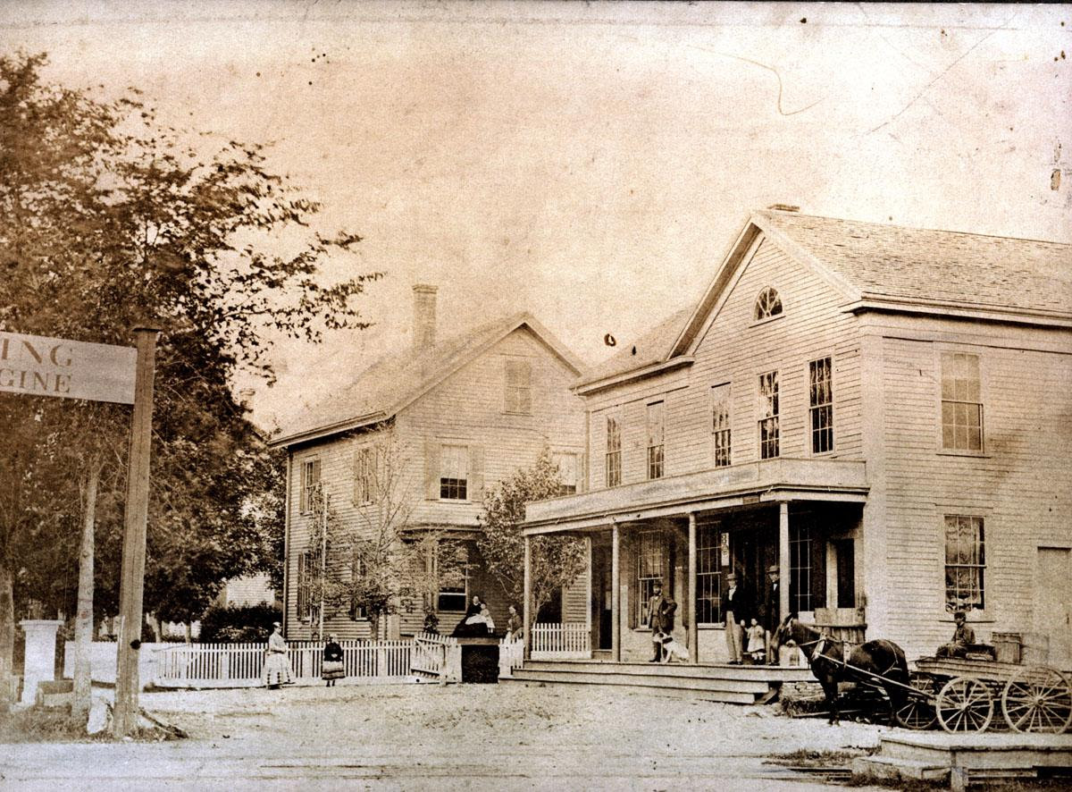
The New Center (Village Hall), circa 1865
Village Hall was built by Stephen Harvey in 1854. It was the first commercial building in the Great Plain. Harvey built it just one year after the railroad line was built, moving quickly to take advantage of proximity to the new form of transportation. Up to this point, the Great Plain was sparsely settled, with only a couple of houses along the road. Its comparative vacancy was one of the reasons that the train line ran through it, rather than crossing the old center on Central Avenue.
The picture shows Village Hall and the house of Frederick Marchant beside it. They were located on the site that is now the Needham Bank, between the railroad tracks and the corner of Garden Street. In the foreground edge you can see the tracks, and at the left edge is the Railroad Crossing (“Look out for Engine”) sign. On the Hall’s first floor was a general/grocery store and the Post Office. The second floor was a meeting hall, used for a variety of purposes, such as the first meeting place for the new Congregational Church in 1856.
Village Hall was purchased by Obed Parker in the 1860s and became known as Parker Hall. In 1869, Parker renovated the building, adding an additional story and a mansard roof along with some more modern ‘Italianate’ details along the windows and porch. The building continued to be used for a mix of retail and town purposes, including (briefly) as the location of the new High School, and town offices after the split from Wellesley. Both Parker Hall and the Marchant house next door were destroyed in 1882, in a fire that resulted when burglars tried to blow open the Post Office safe.
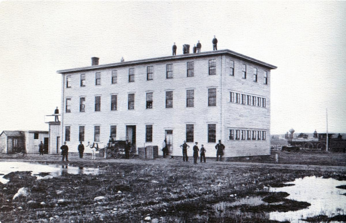 Carter’s Mill #1 under construction, 1864
The William Carter Company Mill #1, 1864
Carter’s is an international business, reputedly the largest maker of children’s clothing in the world. But it started here in Needham, on a single hand-worked knitting frame. William Carter arrived in Needham in 1857, from Alfreton in Derbyshire, England. He, and his father and grandfather before him, had been hand-loom knitters. The rapid industrialization of the textile industry in the English Midlands in the 1830s and 40s threw the hand-loom knitters out of work. Some chose to take jobs in the mills – dangerous and poorly-paid – while many, like Carter, chose to emigrate.
When Carter arrived in Needham, he had little beyond his knitting frame and the clothes on his back. He borrowed some money from a fellow Englishman who had been here longer, and set up his loom in his home and got to work. He was soon able to send back to England for his wife, and hire a few helpers for the knitting, and pay back his debt. Carter was not only hard-working, but he was also (as we would now say) entrepreneurial. He took his sweaters around to vendors and made deals for bulk orders. Soon he was earning enough to buy a second house to use as a workshop.
In 1864, Carter and his brothers-in-law John and Mark Lee went into business together. They built their first factory that year on the corner of Highland Avenue and West Street – a site that would continue to expand and be the headquarters of the Carter Company for the next 125 years. The picture shows the construction of that first mill in 1864. The exterior structure looks substantially complete, but there are still work sheds to the left and the yard is a rutted and muddy mess. The mill was built alongside the train tracks for the easier shipment of goods and materials; a locomotive can be seen in the background.
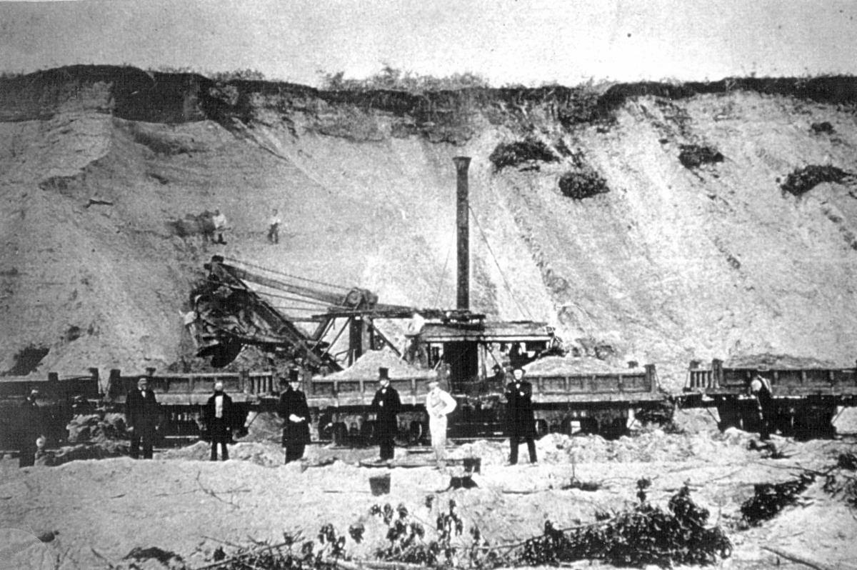 Digging gravel in Needham Heights, 1858
The Back Bay Fill, 1858
Needham Heights used to be higher. As high, in fact, as the hill that the Sheraton now sits on. In the thirty years between the 1850s and 1880s, gravel was dug from the beds in Needham Heights and carted into Boston to fill in the Back Bay from Massachusetts Avenue to Charles Street. The Boston Common once touched the shoreline of the Back Bay, but the City decided that the area was more useful as residential land to accommodate the increasing demand for city real estate, than it was as a stagnant and filthy repository of the city’s sewage.
In the year 1857, two railroad builders, N.C. Munson and George Goss, won a contract from the Commonwealth to fill in the fetid mud flats of the Back Bay receiving basin. The millions of cubic feet of gravel that were needed to fill Boston’s Back Bay came primarily from Needham and adjacent parts of Newton. Gravel is deposited along river beds, and Needham’s extensive banks along the Charles River were a rich supply. Most of this gravel was dug from the area that is now the Route 128 cloverleaf and the N2 Innovation Center (formerly the Industrial Center).
From the 1857 to 1885, gravel was loaded and transported from Needham to Boston. The work was facilitated by Needham’s new train line, which ran along tracks into Newton, behind what is now Needham Street, to what are now the trolley tracks at Newton Highlands. Steam shovels loaded the cars, which could be tipped on pivots to dump their loads at the end of the line. This picture, which dates to 1858, shows dignitaries beside one of the trains. A worker is loosening the gravel with a pole to help it slide down the slope, where it is picked up and loaded by an Otis-Chapman steam shovel.
As an aside, in 1858 a mammoth or mastodon tooth was found in this gravel bed; I have no idea what became of it, but if I ever do find out, I’ll let you know.
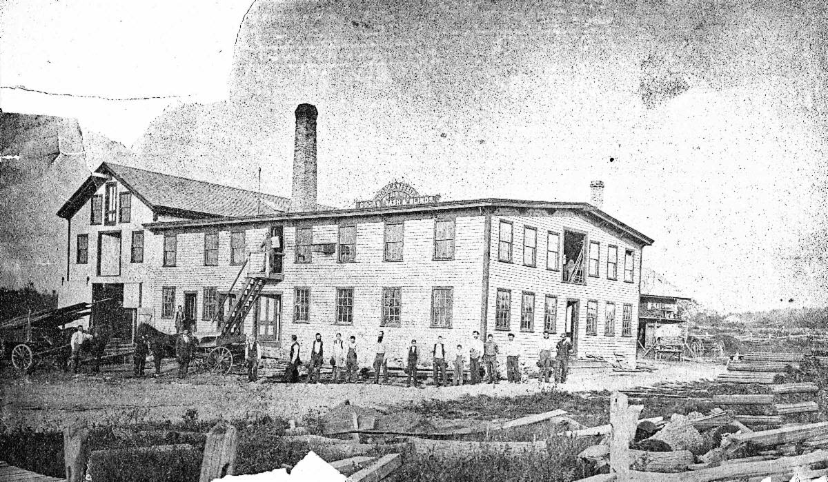 Cook & Webber employees and workshop, circa 1870
The Cook & Webber Company (Doors, Moldings, Sash & Blinds), circa 1870
I know so little about this company! It was located on Highland Avenue between what is now Mellen and Morton Streets. The Webber brothers owned a steam-powered planing mill. A planing mill is an operation that takes raw lumber and cuts it into boards and pieces of regular size. It can also create moldings and additional embellishments. This business ran under the names of Webber Brothers, Cook & Webber, and Bemis & Webber. I believe that Bemis & Webber was its last incarnation; Cook & Webber was probably second, after Webber Brothers.
In the foreground of this picture is a pile of logs, presumably waiting to be planed. Stacked neatly along the right edge are finished boards and moldings. The factory has a lot of nice windows and doors; well, of course it does. There are 20 men in this photo (some harder to find than others) ranging in age from the elderly gent near the exterior staircase, to the young boys near the right end of the row. Also a dog. The elderly gent and the man next to him in front of the horse are wearing ties – maybe Messrs Cook and Webber?
It was hard to pin down the exact date of this photo – probably around 1870-75. Webber may have been in business by 1860; Cook & Webber only shows up in the Town Reports in 1874, and by 1876 they are Bemis & Webber. By 1880 the factory had been sold to John Mills, and in 1883 that location became the Moseley Knitting Mill. Apparently a fire damaged or destroyed the factory around 1878/1880 (all that wood!), so it is not clear whether the Moseley mill included parts of the old planing mill or not.
The town was developing rapidly in the years these five photos were taken. Between 1860 and 1880, the population doubled, from 2700 to 5300. Thanks to the train, the new center at the Great Plain flourished, with new businesses and new residences filling in the once-empty pasture. Also thanks to the trains, Needham Heights was becoming a center of local industry that would power the economy of the town for decades. Needham was on its way to becoming the town that is familiar to us. In these ancient and slightly blurry photos is captured the very moment of that transition.
| Gloria Polizzotti Greis is the Executive Director of the Needham History Center & Museum. For more information, please see their website at www.needhamhistory.org. |