Needham History: “Without which we canNot be hapy”
Dedham was being mean to us.
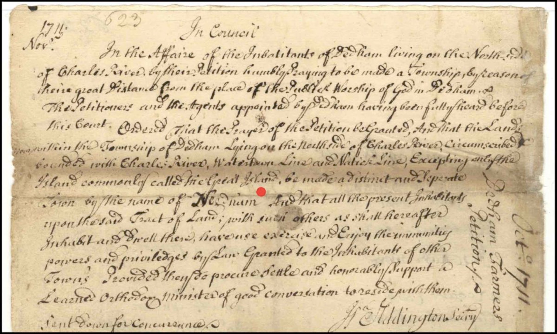
The decision by the General Court to incorporate the Dedham lands north of the Charles River as its own town, to be given the name of Needham. Dated November 6, 1711. This is the very first written use of our town’s name, and appears in this image next to the red dot.
“Without wch we canNot be hapy”
In Council
In the Affaire of the Inhabitants of Dedham living on the North side of Charles River, by their Petition humbly Praying to be made a Township, by reason of their great Distance from the place of the Publick Worship of God in Dedham, and The Petitioners and the Agents appointed by Dedham having been fully heard before this Court. Ordered that the Prayer of the Petition be Granted, And that the Lands within the Township of Dedham Lying on the North side of the Charles River, circumscribed and bounded with the Charles River, Watertown Line and Natick Line, Excepting only the Island commonly called the Great Island, be made a distinct and Separate Town by the name of Needham. And that all the present Inhabitants upon the said Tract of Land, with such others as shall hereafter Inhabit and Dwell there, have use exercise and Enjoy the immunities powers and priviledges by Law Granted to the Inhabitants of other Towns Provided they do procure Settle and honorably support a Learned Orthodox Minister of good conversation to reside with them.
In the House of Representatives,
November 6, 1711 – Read, & Concurred
[signed] John Burrill, Speaker
This is the happy conclusion of the Dedham Farmers Petition, the legislation that separated Needham from Dedham in 1711 and established it as a separate town.
When the Dedham Grant was chartered in 1636, it stretched from what is now Wellesley and Natick, all the way down to Wrentham and Plainville. Settlements within this area were few and small in the 17th century; the closest were those that could travel with reasonable ease between their farmland and the church in Dedham – the area we now know as High Street and Court Street, where the First Church still stands.
However, enterprising souls struck out northward right away, to lay claim to that most valuable resource – land. The oldest European object in the History Center collections is a little slip of paper, a land deed from Dedham to John Kingsbury, dated 15 August 1636, claiming land in what is now the area just over the Dedham town line on Great Plain Avenue. Most of the land in this deed was waste, swamp, and meadow (it still is). It was not very good for building a house, but because it was not wooded (unlike all the drier land) it did not require the great labor to clear, so was highly valued for pasture.
Separation from Dedham was not the first choice of the families living north of the Charles River. In 1708 these farmers requested that Dedham let them establish their own parish – their own church and minister – within their area of Dedham. The request was made, and refused, at least three times in 1708 and 1709. It was repeated in March 1710, and then again in May 1710. This refusal prompted the petitioners to address a higher authority and direct their request instead to the General Court. This time, clearly frustrated, they sought a full separation, rather than the convenience of their own parish.
The document identified in the MA State Archives as “The Dedham Farmers Petition to be a Township” was filed with the General Court in May 1710. The overall reason for such a move was that the residents of the northern part of the Parish (that was us) were having increasing difficulty in attending weekly church services because of the great distance to Dedham, and that to be deprived of the consolations of religion was detrimental to their souls: “there is Already settled [in this area] upwards of forty & five famylies, many of which by reason of their Remote Living from ye place of ye publique Worship of God in our Own Town, Some 6.7.8.&10. Miles. Which Renders it Utterly Impossible for us with our familyes, Duly to Attend On ye publique worship of God there… And To Starve our own Souls, & ye Souls of our poor Children that he hath given us ye Charge of – “, concluding ominously that “this Honerd Court, And your honers Will Judge what May be Expected of A people That Cannot Injoy, Either the Means of Education Manners, Nor Grace…”
After the emotional religious plea, the petitioners also listed three more pragmatic reasons that this separation was a good idea:
One, that there were already 45 families in town. This hearkens back to some of Massachusetts’ oldest laws governing public education. The law specified the requirements of an incorporated town to be a church, a public school, and the means to support a minster. For larger towns, a schoolhouse was required for every fifty families. The petitioners were pointing out that they were (a) asking for their own minister, and (b) with 45 families, they were going to require their own school very soon anyway, so they were already most of the way toward township.
Two, the church was a long distance away. Although we can make the trip by car in about 15 minutes, travel to the First Parish in Dedham (still on High Street) on foot or by oxcart, could take two to three hours or more, each way. Travel by foot or cart moved at about 2 miles per hour. Moreover, because of the chronic winter flooding of the Charles, they were not even able to get to Dedham for several months of the year, and were therefore excluded from church, school, and Town Meeting – that is, from every single privilege of citizenship.
And Three, trying to first resolve this matter with Dedham only made the situation worse, and that as a result they have met with “Storms in Opposition from their Owne Towne” and “Afterward Mett with Such hard Measures from their Town as have been hard to Bare…” In other words, Dedham was being mean to them. Not only was Town Meeting not willing to negotiate a solution, but the repeated attempts had fostered increasingly bad feelings between the two parts of town. The Farmers ultimately decided on separation because “we Desire peace & Quiet Ness in ye Injoym’t of ye favours petetioned for, Without wch we canNot be hapy.”
The Petition was read in the General Court in June 1710, and a notice was served on the Selectmen of Dedham to submit a prompt reply. Dedham requested an extension until the May session in 1711; this was granted, but Dedham was also advised that they should go about finding a minister to preach in the northern part of town in the meantime.
Dedham reported to the Court on 28 May 1711 that they were in favor of the incorporation of the northern farms into a new town, but that the boundary should run from what is now the bridge on Kendrick Street, southwestward to the Charles just beyond Chestnut Street – roughly one-eighth of the land requested. The Farmers countered in June that this boundary was in violation of property agreements that dated back into the 1600s; plus, Dedham never paid for the interim minister, so they had to raise the money to pay him themselves.
The Court ruled in favor of the Petitioners on November 6, 1711, setting the boundary as originally requested – bounded by the Charles River for most of its circumference, and by Newton Upper Falls (the “Watertown Line” in those days, as Newton was still part of Watertown), and the “Natick line”(south of Dover Road), with the exception of the Great Island (the river loop where Great Plain Avenue crosses into Dedham), which remained part of Dedham. Royal Governor Joseph Dudley consented, and granted the new town the name of Needham, after a town in Suffolk, England.
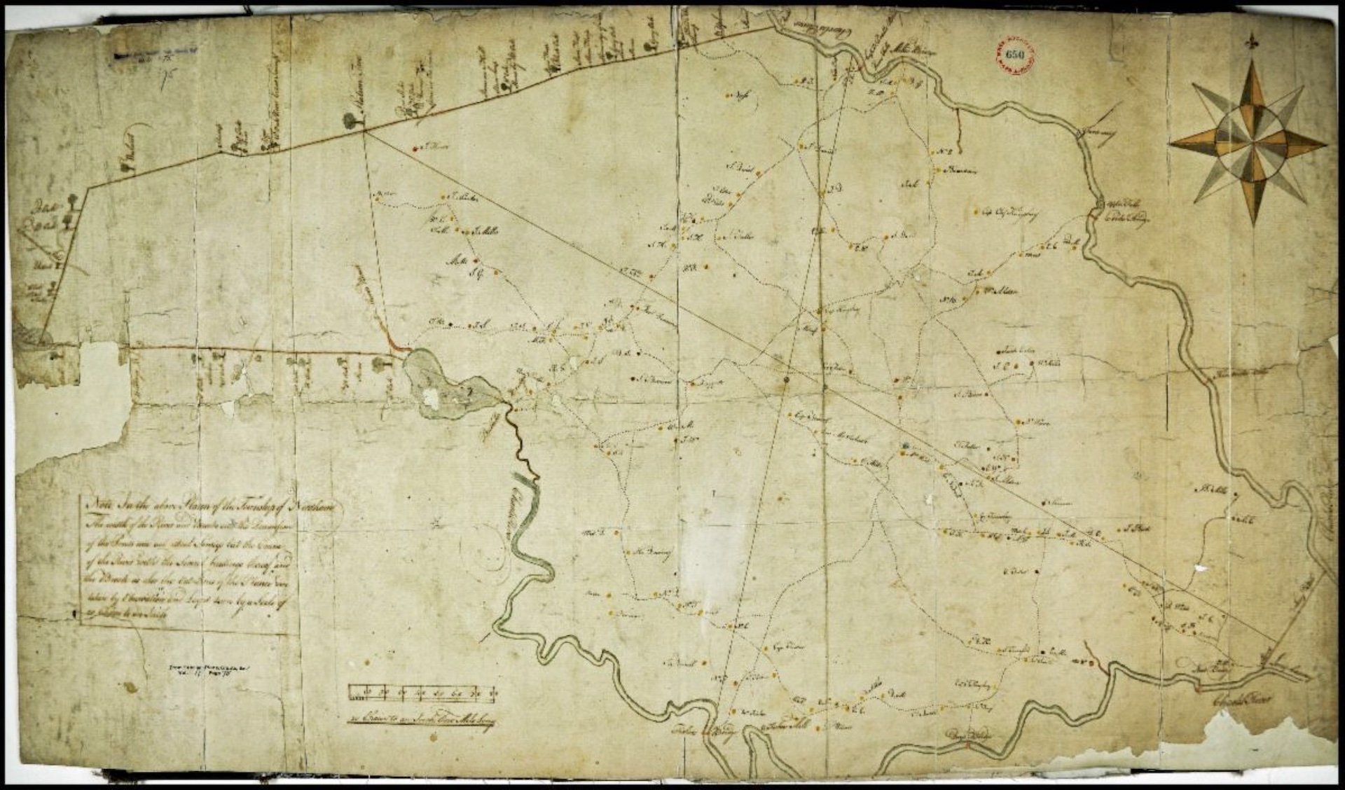
A look at the oldest map of Needham (by Barachiah Mason, 1771) shows that the original boundaries were much different than today, and the town was much larger. The extension to the west, known as the “Needham Leg” (now part of Natick) went back and forth between Natick and Needham, finally becoming a part of Natick permanently after the Revolutionary War. The western half of the map separated in 1881 to become the town of Wellesley. The final split with Wellesley was over economic and social issues, but the antagonisms dated back to the 1720s – ironically, over difficulties in traveling to the meeting house.
The 1771 Barachiah Mason map of Needham shows Needham in its original configuration, which included what is now Needham, Wellesley, and parts of Natick.
| Gloria Polizzotti Greis is the Executive Director of the Needham History Center & Museum. For more information, please see their website at www.needhamhistory.org. |