Needham History: The Ministerial Lands
Keeping the Minister fed and happy.
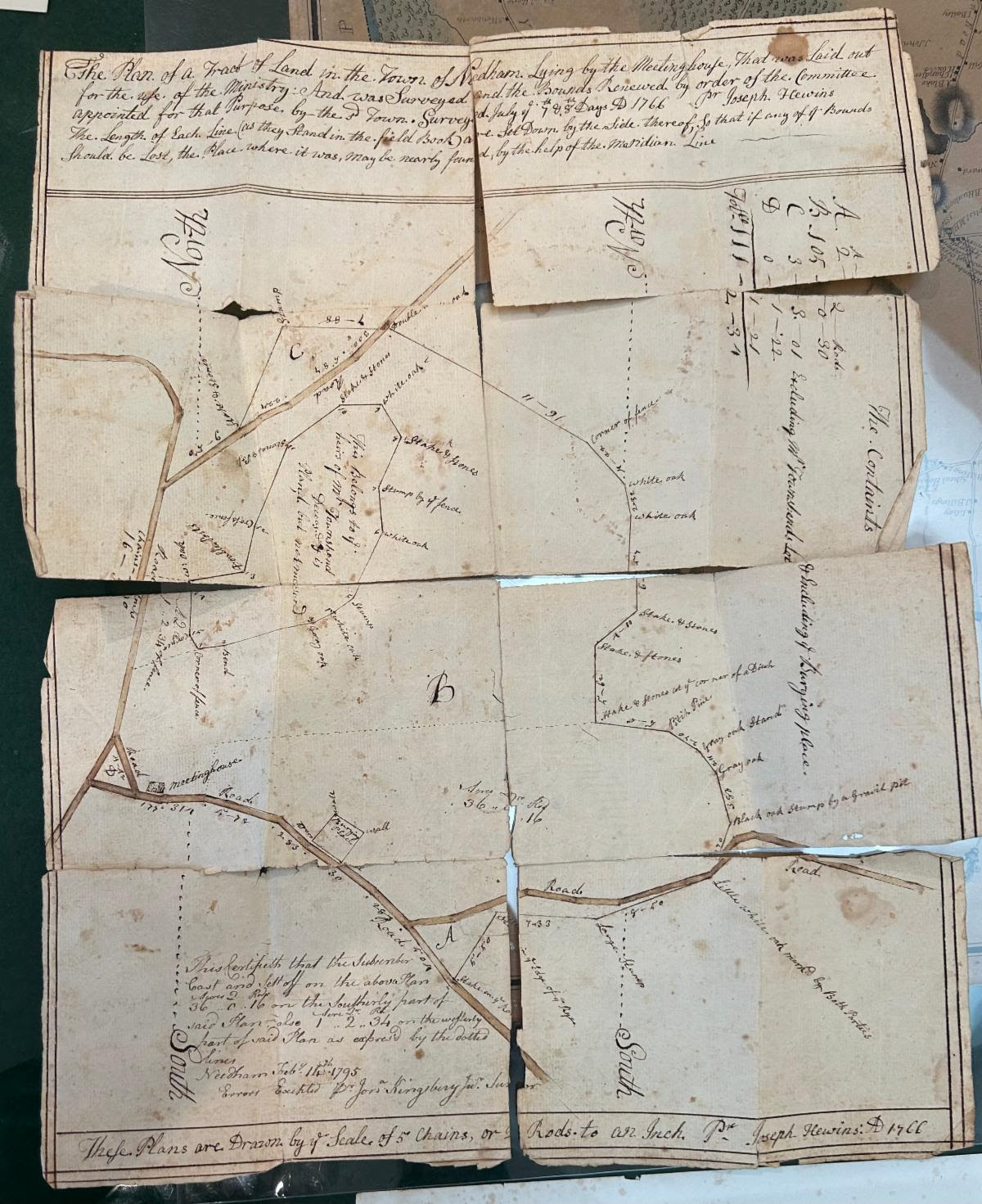 The Joseph Hewins survey of Needham’s ministerial lands, dated 1766. The paper is in tough shape, but the ink is still clear and bright. It is about 8 x 11″.
The Ministerial Lands
“The Plan of a Tract of Land in the Town of Needham Lying by the Meeting House, that was laid out for the Use of the Ministry. And was Surveyed and the Bounds Renewed by order of the Committee appointed for that Purpose by the said Town. Surveyed July ye 7th and 8th Days AD 1766 Dc [Deacon] Joseph Hewins.”
In October the Needham History Center received a delightful surprise and an excellent gift from our friends at the Canton Historical Society. Canton’s archivist was working on their collections and came across a hand-drawn 1766 survey of the Needham Ministerial Lands. Since it did not have any bearing on Canton’s history, they offered it to us. Yes – thank you!
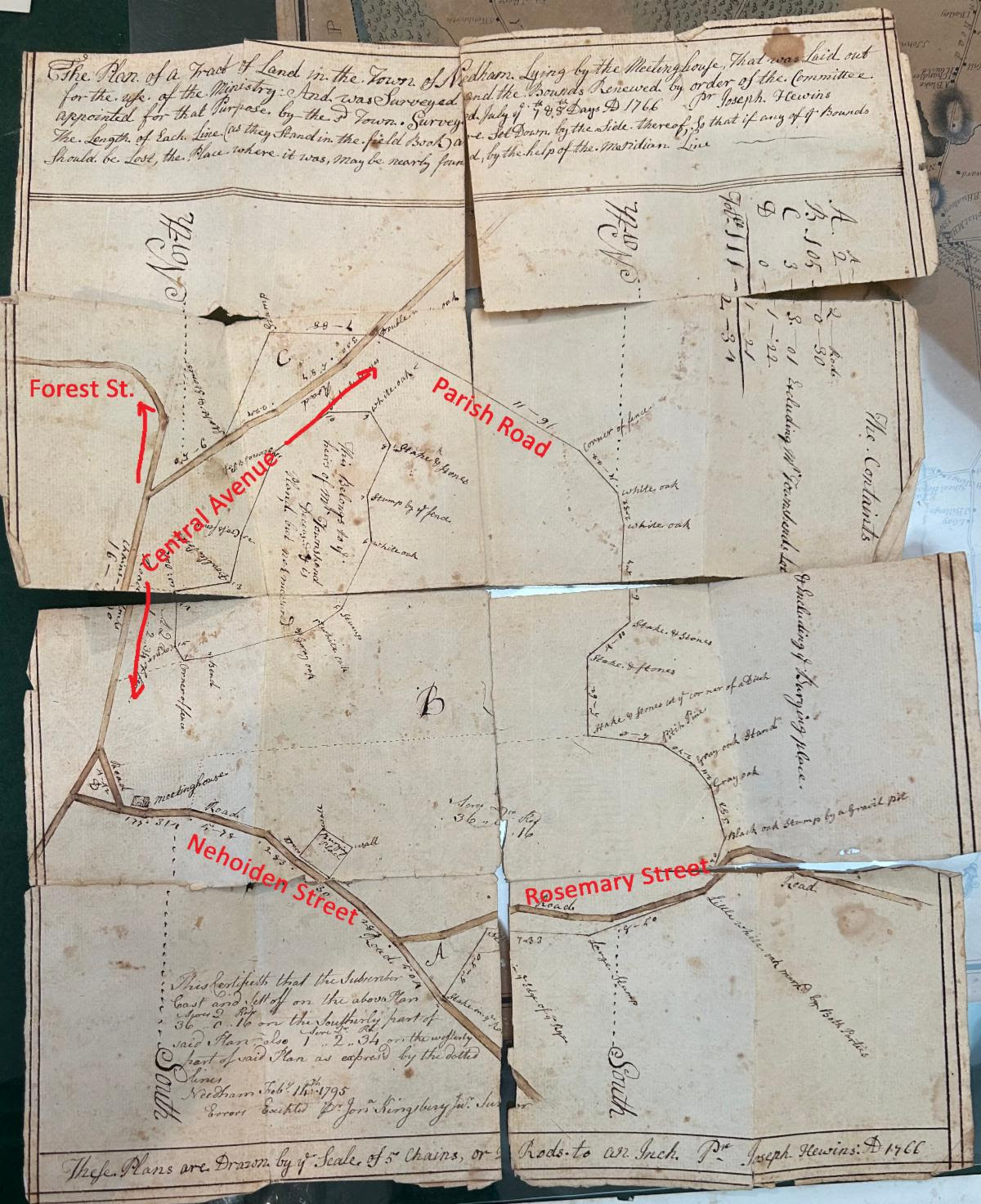
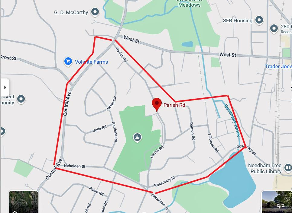
The map was folded up sometime in the long past, and is now quite fragile and broken at the seams. Nevertheless, the image is clear and detailed. It shows the junctions of Nehoiden Street with Parish Road and Central Avenue, and Rosemary Street.
But what are the Ministerial Lands? In colonial Massachusetts, a town was defined by a church, a school, and the resources to support the minister. The ministerial lands were plots of land set aside for the maintenance of the Minister – a home lot, woodlots, land for growing crops and for grazing. The intent was to create a stable economic foundation for his household and to thereby insure that the minister would stay for a while. Other than the obligation to provide for his support, there was no regular system of taxation in the early 1700s that would guarantee a the minister a salary, so the land was the main resource.
Therefore, the legal establishment of a town entailed the laying out of the ministerial lands. Usually the plots would be designated by a committee, who then had to provide the General Court with a list and map. Once designated, these lands became public property in the sense that their resources could only be used for the public good (ie, keeping the minister fed and happy) and not for private use. Typically, the ministerial lands were held in trust for the minister and his successors, and were managed by the Selectmen or a committee designated by them. Thus, they were reserved “for the ministry from one generation to another for ever and not to be Sold nor alienated from the ministry forever but to remain for the publick use for the ministry.” They could therefore not be sold or altered without the approval of both Town Meeting and the General Court.
A settled minister was more than just a figure in church. At a time when church and state were united, the minister was the town’s civic leader alongside he selectmen, and its single spiritual authority. Attracting an educated minister (from Harvard, as nearly all of them were in those days) and keeping him settled for a long time were significant aspects of maintaining the welfare of the town in all spheres.
The survey plan annotated with the current road names.
In Needham, there were two designated lots of Ministerial Lands, totaling about 143 acres – 141 acres bounded by Central Avenue, Nehoiden Street, Rosemary Street, and Parish Road; and two acres on Central Avenue opposite Parish Road. These are the lands depicted in the map. These lands were designated and remained for ministerial use from the time of the town’s founding in 1711 through the ministry of William Ritchie, the third minister, in 1842. Though by Rev. Ritchie’s time, some of the land had been sold off for other town purposes.
And although we know something about the ministerial lands themselves, we also know something about this particular map. It was required from time to time to survey the ministerial lands to make sure that the boundaries still held and that no one had encroached. This survey, as also mentioned in the text at its head, was made by Deacon Joseph Hewins in 1766. The town records that the town paid three men for assisting him – Nathaniel Fisher (14 shillings), Deacon John Fisher (7 shillings) and Michael Metcalfe (3 shillings); and paid Amos Fisher and John Day 19 shillings between them for feeding the men during the work. Oddly, it does not record what Joseph Hewins was paid for the actual survey, but it does note that the committee wanted to sell some wood from the lands to pay the bill and Town Meeting voted the request down.
In the manner of the time, the survey landmarks are large features that most people would recognize and which could not be easily moved – mostly trees and stone walls. Sometimes a less permanent (thus moveable) object was used (usually a stake supported by stones), which is why the survey needed to be verified periodically. However, there is also a note in the bottom left corner from Jonathan Kingsbury dated 1795, noting that some of the land had been set off since the 1766 survey; this was presumably noted as part of the town-wide boundary survey that he made the year before.
Because the landmarks were ephemeral – the “white oak,” the “pitch pine,” etc, it is hard to define the actual boundaries at this point. The clearest indicators are the main streets that are shown – Nehoiden Street, Central Avenue, Rosemary Street, and Forest Street.
This little map is the oldest map of Needham land that we possess, and the earliest survey that I have yet seen. Before that, the oldest full map that has been identified is the Barachiah Mason map, surveyed in 1771 and in the collections of the MA State Archives. It is also proof that thanks to dedicated colleagues and some happenstance, delightful things can happen on any day.
The approximate area of the ministerial lands as surveyed, seen on a modern map of Needham.
| Gloria Polizzotti Greis is the Executive Director of the Needham History Center & Museum. For more information, please see their website at www.needhamhistory.org. |