Needham History: Location, Location, Location
Was Pilfershire the abode of thieves…?
Location, Location, Location!
“Granted [by the Town of Dedham] to Thomas Metcalfe and to his Heirs and Assigns forever four acres of Swamp, more or less, near Strife Meadow … abutting upon waste land and swamp in part East and South and upon waste swamp north …” [dated 1705].
Wow! Four acres of swamp in Strife Meadow – abutting on even more wasteland and swamp – forever! Who could turn down a sweet offer like that?
Actually, though it sounds like an undesirable property to us, Thomas Metcalfe was actually getting a pretty good deal. Wasteland and swamp were not wooded, so they did not have to be cleared for grazing. Clearing woodland was a slow and laborious process. Metcalfe (and his fellow early-Needhamites) were looking for land on which to graze their cattle, and swampland was practically ready-made pasture. Plus, it was never short of water, and cows need a lot of water.
But where is Strife Meadow?
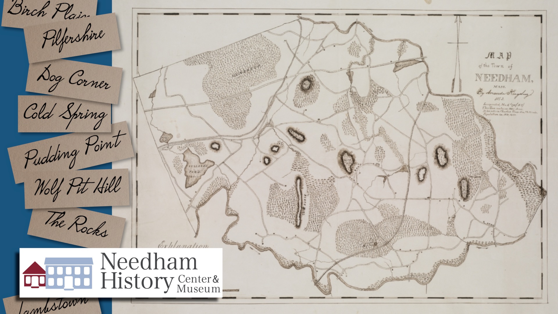
Needham’s landmarks were very different in past centuries, when descriptive place names did the job that addresses and street names do now. We have High Rock (though it seemed higher then), the Broad Meadows, Rosemary Meadow (now flooded to make the Lake) and the Great Plain – we still use these names after almost 400 years. But where is Cold Spring, or Dug Hill, or Birch Plain? We will try to avoid getting mired in Pine Swamp Neck. Was Pilfershire the abode of thieves? Wolf Pit Hill sounds dangerous, but Lambstown seems nice and safe; let’s just hope they were not next to each other.
Finding these places now is not always easy. Sometimes the name is functional or descriptive and forms a clue, and sometimes tracking down the property owners on the old maps does the trick. It helps if the name stayed in use for a long time, but many of these names changed over time, or just became obsolete. Here are a few that I could identify:
- Cold Spring was the area near Riverside Street, where Highland Avenue crosses the Charles River. In the mid-19th century, there was a paper mill there, owned by Otis Pettee. Around the turn of the 20th century the mill had become the Saco- Pettee Machine Shop (cotton milling), with a cluster of worker’s houses around it (the current muffler shop site and the businesses across the street, just before the bridge). There was also a boat house onto the river. The area was known as Cold Spring into the early 20th century.
- The Rocks was the area of Central Avenue where there are extensive rock outcrops – Claxton Field, and especially the area that is now the horse farm; the name was in use by the 18th century. Dug Hill was across the street, near the Pine Street and Starr Ridge intersections.
- Birch Plain is the section of Great Plain Avenue near the Wellesley line – now Mary Chilton Road and Powder House Circle.
- Pilfershire is the section of Central Avenue between Great Plain Avenue and Marked Tree Road – wow, the Needham History Center is in Pilfershire! Dog Corner is right near by – the intersection of Great Plain and Central Avenue. The name is said to derive from the large and noisy packs of hounds kept by the Mills family, who owned several houses at this intersection.
- Pudding Point was later known as Greendale. We still know Greendale Avenue, but the road basically ran through a section of town with the same name. The Greendale neighborhood encompassed Great Plain Avenue and Greendale Avenue south of Broadmeadow Road.
- Wolf Pit Hill was just east of where Chestnut Street crosses the Charles, and dates back into the mid-1600s. Massachusetts used to have a large population of gray wolves, and they preyed on livestock. MA established a wolf bounty in 1630 – a reward for every dead wolf. Many towns had wolf pits and wolf traps. The effort was clearly successful, because wolves became extinct in MA by 1840. Wolves are moving back into the area, but there is not yet a stable breeding population.
- Ox Meadow was also on South Street, the area around Farley Pond and south toward the Charles River. This area is damp and swampy, and subject to seasonal ponds. This is, as mentioned above, perfect wet meadow for cattle grazing – as the name implies. I do note, however, that it is distressingly near to the Wolf Pit; but then, oxen are quite large.
- The Hundreds was a huge triangle of wooded land, bounded by the current Washington Street and Weston Road in Wellesley. By the mid-1800s, roads and settlement began to encroach and reduce the size of the woodland.
- The Chestnut Trees was a woodlot east of Forest Street, toward Brookside Road and the area around Sunita Williams School. The name goes back to the 1700s, but even in the 1800s that area was wooded.
- I have to confess, I still have not located Pine Swamp Neck, Neckfield, or Lambstown. Pine Swamp Neck may be a part of the Pine Swamp, which incorporated the land we now know as the Nike Site and the eastern edge of the Ridge Hill Reservation.
Despite their eternal rights of ownership, the Metcalfes no longer live in Strife Meadow. Actually, their rights were not really never-ending – “forever” in 18th century deed parlance meant that they owned the property outright without encumbrances and had all of the land ownership rights recognized by law. They could – and eventually did – sell the land. (Many thanks to Needham resident and Boston College Law Professor Mary Bilder, who provided the definition of “forever” in this historic property context).
By the 19th century, the Metcalfe’s land took the names of new owners, and Strife Meadow Brook became Dewing Brook, and then Fuller Brook. The Meadow now lies on the Wellesley side of the line, between Washington Street and Dover Road, as the site of the Nehoiden Golf Club.
Most of the names were descriptive – the pine swamp, the wolf pit – and changed as usage changed or as ownership changed. However, I still remain puzzled by a few. I come to Pilfershire every day to work – and I have yet to see bands of thieves. Interestingly, I can’t find an English counterpart, but there was also a Pilfershire in CT – a ghost town that was part of Simsbury in the 1700s and 1800s, apparently abandoned as the result of fires and neighborly altercations. Which brings us back to Strife Meadow. I tried in vain to find a usage that was a variant of the marsh plant “loosestrife,” but I suppose that is still a possibility. Otherwise, I shudder to think of what conflict, what ancient Needham Hatfield-McCoy feud was once memorialized in the name of this place.
| Gloria Polizzotti Greis is the Executive Director of the Needham History Center & Museum. For more information, please see their website at www.needhamhistory.org. |